About Smederevo
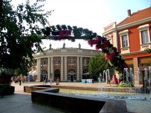
The city of Smederevo is located in central Serbia, and is the administrative center of the Podunavski district. It covers an area of 481.5 km and is bordered by the Danube on the north, the Velika Morava on the east, and the Sumadija hills to the south and west.
The roman settlements of Mons Aureus and Vincea use to be on the spot of modern-day Smederevo. Smederevo was first mentioned in the 1019 AD Charter by the Byzantine Emperor Basil II, under the name of "Sphenteromon". There is a clear distinction in the landscape between the lower, eastern part, with an average altitude of 85.0 m (Pomoravlje) and the higher, western part with an average altitude of 169.2 m (Sumadija). The climate is moderately continental.
There are 117,134 inhabitants living on the territory of Smederevo, 83,768 of which live within the city and its outskirts. The population density of the municipality in 2006 was 243.27 inhabitants per km.
Smederevo Transportation Connections

The Smederevo municipality has an extremely favorable tourist geographic position within Serbia. It is:
– On the international E-75 highway, Corridor 10 which connects Budapest, Belgrade, Nis, Thessalonica and Athens.
– Located on the international railway line connecting Budapest and Belgrade with Athens and Sofia.
– On the most attractive part of the Danube riverbank in Serbia, with a shore that is suitable for constructing ports and marinas, with nearby industrially developed areas, on the international Corridor 7.
– 45 km from Belgrade, the administrative, economic and touristic center of Serbia.
– The "Nikola Tesla" international airport is situated 60 km from Smederevo.
Map
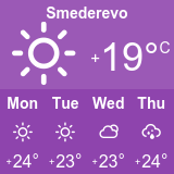
Current Weather
You Might Also Like...

Tourist Info Centre
Visitor and Tourist Info Centres are there to help you make the most of your visit to the city of Smederevo and it should be your first stop when arriving in the city.

Getting To Smederevo
To reach Smederevo from Belgrade there are at least a dozen or so buses a day (every 30 minutes) from the Lasta bus station.